
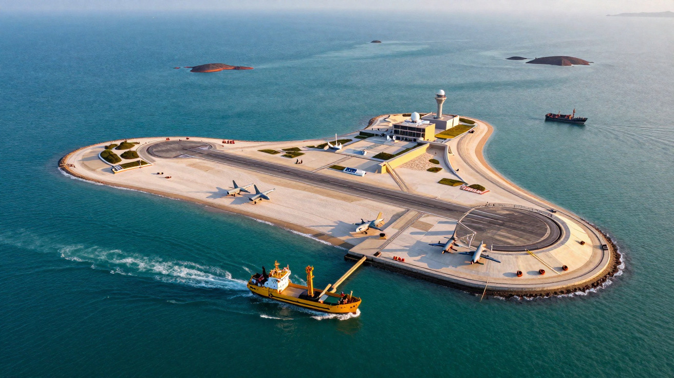
Just the tap of small waves on the hull, the buzz of a drone somewhere in the distance, and the imposing outline of a runway emerging from what was once open water. A Filipino fisherman peers at the grey concrete, counting radar domes as though they were gathering storm clouds. Twelve years earlier, he had thrown his nets over shallow reefs here. Now, a Chinese airstrip cuts across the horizon, bordered by hangars and fuel tanks.
On his phone’s maps, the area still appears as blue water and sandy shoals with attractive names. Standing nearby, however, it feels like something far bigger than a dispute over a reef. The reef became an island, and the island became an argument visible from space.
Somewhere below that concrete, the former seabed has disappeared.
From shifting sand to fixed power
Viewed from above, the South China Sea appears almost peaceful: an expanse of turquoise shallows interrupted by pale coral circles and faint shipping-lane tracks. But then the geometry stands out - straight lines, sharp corners, runways and roads. The sea did not create these features. They are the marks of dredgers, underwater bulldozers that have torn up the seabed since around 2013 and deposited it as new artificial islands under a red flag.
China did more than place a handful of extra points on a map. It transformed the region’s character. A dispersed collection of reefs and rocks - difficult to occupy and costly to supply - became a network of fortified outposts. Once concrete meets coral, disputes that had seemed theoretical begin to look impossible to compromise over.
Consider Fiery Cross Reef, called Yongshu in China and Đá Chữ Thập in Vietnam. In earlier satellite photographs, it was a thin strip of reef that barely rose above the water at high tide. By 2014, dredgers were working around it, drawing sand from the seabed and throwing it over the reef in a manufactured storm. Within a few years, the narrow feature had expanded into an island of roughly 270 hectares, with room for a 3,000-metre runway, reinforced shelters, a deep-water harbour and radar towers.
Vietnamese fishermen recount being turned away by Chinese coastguard ships that had not previously operated there. Pilots from other countries now describe receiving warnings to leave “Chinese airspace” in places their grandparents would have called the high seas. These are more than newly created islands. They have introduced new patterns of behaviour in the air and at sea, imposed every day by real ships and persistent administration.
The legal shift is as striking as the physical one. Under the UN Convention on the Law of the Sea, rocks submerged at high tide generate neither territorial seas nor economic zones. Land that has always remained above water is treated differently: it can produce 12 nautical miles of territorial sea and, in certain circumstances, a 200-nautical-mile exclusive economic zone. By converting submerged features into permanent land, China has blurred that divide in practical terms, even while lawyers maintain that nothing legally changed.
That is the understated effectiveness of dredgers. They do not alter treaties; instead, they change the facts on the ground and challenge others to regard them as temporary. Each airstrip, harbour and radar dome turns an unresolved issue into an everyday condition. Maps can be negotiated. Concrete and runways are far more difficult to undo.
How China turned a reef into leverage
The process itself is starkly straightforward. Survey ships and coastguard cutters are sent first, sometimes with naval escorts, to “patrol” claimed features. The dredgers follow - vast vessels that suck sand and silt from around a reef before firing the slurry over coral like a fire hose. Across the following months, coral heads vanish under rising layers of sand, stone and crushed reef. Engineers then move in, driving piles, installing foundations and pouring concrete until an island takes shape.
China has repeated this process across at least seven major features in the Spratly Islands. Subi, Mischief, Gaven, Johnson South and Hughes - once names found mainly on naval charts - now feature in defence briefings and news alerts. The development sequence is familiar at each site: helipad, pier, radar, accommodation, runway. What may be described as “reclamation” is, stage by stage, deployment.
At a human level, the new bases have produced an unusual daily choreography. Filipino and Vietnamese captains say they weave between Chinese coastguard vessels to reach long-used fishing grounds. American and Australian pilots conduct “freedom of navigation” sorties and repeatedly hear the same standardised radio warnings from Chinese controllers. Many people know the feeling of seeing a childhood place suddenly fenced off; in the South China Sea, that sensation advances mile by mile as fresh sand emerges.
For other states in the region, the most frequent error was initially to see these schemes as symbolic. It is easy to dismiss heaps of sand. Let us be honest: hardly anyone spends every day examining satellite images to measure the expansion of a new pier on an isolated reef. That is why many felt the change had occurred overnight. In fact, the 12 years brought a continuous trickle of dredging, building and normalisation, while competitors debated statements rather than maintaining a presence.
Saying “They built islands” tells only half the story. The more significant step was constructing what those islands make possible: layered power projection. Radar can monitor wide stretches of sea and airspace. Runways can support fighter aircraft, patrol planes and drones able to remain airborne for hours. Deep-water piers allow large coastguard and naval vessels to refuel and resupply without returning to Hainan or the mainland. This network enables China to maintain continuous oversight of tankers and warships passing through the area in a way that ships afloat alone seldom can.
Trace the three major airstrips on a map - Fiery Cross, Subi and Mischief - and they form an approximate triangle, a forward-base network covering much of the Spratly region. Add the smaller positions equipped with radar and missile platforms, and overlapping zones of surveillance and possible firepower emerge. No shot has to be fired for those zones to alter choices. Insurance premiums gradually rise. Captains select longer, safer passages. Smaller states discreetly adjust their language to avoid provoking aerial displays above their patrol vessels.
“This isn’t about a few rocks and reefs,” a Southeast Asian diplomat told me during a regional forum. “It’s about who gets to set the rules in the world’s busiest corridor without saying that out loud.”
Officially, the world responded through arbitration cases, communiqués and firm declarations in support of freedom of navigation. In reality, the dredgers continued. This is the aspect that particularly frustrates officials in Manila, Hanoi and Kuala Lumpur when they speak off the record. While others disputed the law, one player repeatedly converted legal uncertainty into physical reality.
- China changed more than geography; it changed daily risk calculations for every vessel and aircraft in the region.
- Artificial islands drew coastguard and militia vessels towards them, squeezing out less powerful neighbours.
- The regional balance of power moved quietly, one barge-load of sand at a time.
What this new seascape means for the rest of us
For those living far from the region, this may seem like a remote storm: reefs, dredgers and acronyms. But the consequences reach directly into ordinary life. Around a third of global shipping travels through the South China Sea, including tankers transporting Middle Eastern crude to East Asia and container ships carrying electronics, palm oil and grain. Disrupting that traffic - or simply making it more costly and fraught - sends price increases towards supermarket shelves on another continent.
This is why navies from well beyond Asia now operate regularly in these waters. The US, UK, France, Japan and Australia deploy ships and aircraft not because the precise shape of Subi Reef matters deeply to them, but because they care who decides which vessels may pass it. The artificial islands are tangible evidence that “freedom of navigation” is not merely a slogan; it is a practice that must be exercised or it gradually narrows.
For smaller Southeast Asian countries, the pressure is more personal and more draining. Each additional Chinese outpost creates another location from which coastguard ships can linger, drones can take off, and maritime militia boats can “bump” or follow local fishermen. Authorities in Manila and Hanoi must decide whether to confront, accommodate or quietly hedge, aware that every option is observed in Beijing, Washington and at home.
The tempting emotional response is to treat this story as unavoidable, as though a great power’s actions were tides - indifferent and unstoppable. They are not. They result from hundreds of choices taken in offices, on ship bridges and in air-traffic-control rooms. Millions of people watch them unfold, yet usually have little influence beyond a ballot box or a social-media post.
That leaves difficult questions for everyone else. How closely do we really follow the governance of our trade routes until a crisis raises fuel costs or leaves shelves empty? When does a distant reef become something felt in a daily journey or a heating bill? One of the quieter lessons of China’s 12-year reshaping of the seabed is that strategic transformation often begins in locations few people ever see, becoming apparent only once reversal is too expensive.
The next stages remain unwritten. Climate pressure will make fisheries less abundant, driving more boats into contested waters. Emerging technology - uncrewed vessels, long-range missiles and swarms of inexpensive drones - will alter the value of every artificial island for both attack and defence. Other countries are already trying smaller versions of the same approach, laying concrete where waves once broke without obstruction.
That is why this story cannot easily be dismissed as “just” about China. It also concerns how any state, having learned that shifting sand can shift borders in practice, may be tempted to imitate the method. The ocean floor, once a shared and changeable commons, begins to resemble a building site waiting to be developed.
| Key point | Detail | Why it matters to the reader |
|---|---|---|
| Artificial islands as tools of power | China used dredging to transform reefs into fortified air and naval bases over roughly 12 years. | It helps explain how construction at sea can quietly alter military and political influence. |
| From legal grey area to daily control | New islands support constant patrols, radar coverage and “de facto” claims over heavily used shipping routes. | It shows why a faraway dispute can affect trade, prices and broader global stability. |
| A model others may copy | The success of this approach could encourage comparable seabed projects in other contested waters. | It prompts consideration of future flashpoints, from the Arctic to other semi-enclosed seas. |
FAQ
- Why did China begin building artificial islands in the South China Sea? Beijing sought to reinforce its broad “nine-dash line” claim through physical presence. Converting reefs into bases provided runways, ports and radar sites that make control more practical, despite continuing legal disputes.
- Are these artificial islands legal under international law? The 2016 Hague tribunal ruling found that China’s expansive claims have no legal basis and that artificial islands do not create new maritime rights. Beijing rejected the ruling and continues to operate the islands as though they support its claims.
- How has this changed the balance of power in the region? The islands enable China to position ships and aircraft farther south, for longer periods and with stronger support. Neighbours now encounter an almost permanent Chinese presence in waters they also claim, tilting day-to-day interactions towards China.
- Does this threaten global trade and freedom of navigation? Shipping continues to move freely, but its risk profile has altered. A crisis could escalate more quickly, while even limited tensions may increase insurance and operating costs for vessels using these sea lanes.
- Could other countries use the same strategy elsewhere? Yes. Several states have the technical capacity for island-building and seabed alteration. This is why observers fear that the South China Sea has become a template for “facts on the water” in other disputed regions.





Comments
No comments yet. Be the first to comment!
Leave a Comment